Toilets of the World
 I saw this in my local bookshop and had to buy it. This obsession with toilet books harks back to 1997 and Adam Harts quite fantastic Thunder, Flush and Thomas Crapper: An Encycloopedia. Now out of print, it is a real classic and home to such anecdotes as a detailed explanation of the double-bend siphonic flush action. Anyone who reads this book must look at the item on “astronauts” and, my favourite, “australia”.
Anyway, a slight digression. Toilets of the World has, as might be expected, pictures (and explanations) of toilets from around the world. A great book to leave in the, well, toilet, and dip in to. El Porvenir airport’s toilet (Panama) is great. The Whiskey Cafe in Montreal, interesting….. and Rothesay Pier (Isle of Bute) is a real tribute to the Victorians (and one I have actually been to!).
Google Maps support for GeoRSS
Ed Parsons gave the heads up on the Google Maps blog news that support has finally been extended to GeoRSS. Bout time too in my books; GeoRSS is rapidly emerging as the de facto choice for lightweight distribution of vector data. And the fact that the OGC have a white paper on the “standard” is good news. Its not as rich as GML (or KML for that matter) but its good at its target market.
At the Journal of Maps we use WorldKit to suck the abstracts for our articles out of a GeoRSS file and display it on the main page. We’ve now add a Google Maps link for those wishing to use it. Having quickly played with it, support is not quite what I like, but its OK. Notice for example the different display of points and polygons; polygons also remain non-clickable whilst points are OK. I’m no expert on the Google Maps API so I’d been interested to see if some of these behaviours can be changed.
Viewing Map Projections
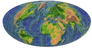 Ever wondered what a Raisz Half Ellipsoidal projection of the Earth look like? Well you do know because its shown on the right! The Map Room points to the Global Map Projector over at NASA which allows you to transform any equirectangular map image into another projection. Really is an easy (and fun!) way to explore the effects of different map projections. Also a very good way of generating bespoke world images for presentations; The Map Room suggests a visit to flatplanet to grab some JPG files from their vast archive of interesting world images to play with.
Area is a standard geometrical property right?
Well you would have thought so wouldn’t you? We have the following simple geometry:
lines: they have a location based upon a start and end point, in addition the have the properties of length and orientation
polygon: they have a location based upon coordinates of the points making up the feature, and also have properties that include a centroid, area and perimeter. There are also other things you might want to calculate including min/max dimensions, maximum bounding box etc
So thats straightforward. OK, so if you want the basic properties you would expect your GIS to be able to calculate at least most of the “basic” properties “out of the box”. Lets take ArcGIS 9.1 as an example:
points: well it must be able to record the point otherwise you wouldn’t be able to see it. Can you get the coordinate? No.
lines: Ditto, so we can’t get the start/end points. Orientation. No. Length. Errrr. No.
polygon: Ditto for points again. Perimeter. No. Area (and, I might add, one of THE original reasons that a GIS preferred to manual calculations). Errr. No.
Well its not strictly correct. All of the above features can be extracted in ArcMap using some good ‘ole VBA code. Now thats nice and easy (not!). Some of them can be extracted using ArcToolBox. Ah, you need the underlying ARC/INFO and, more importantly, the more expensive license for it. The points can also be extracted by exporting in an ASCII format although, yes, you need ArcToolBox. What started all this off? A student asking if they could calculate area as surely that must be easy! No wonder there is an over-proliferation of add-ons like ET Tools, XTools Pro and Hawths Tools. I know ESRI can’t program everything; BUT REALLY. This is elementary geometry.
So am I getting increasingly frustrated with ESRI’s banal minimalist interface that fails to give you easy access to the fundamental underlying geometry? Yes. The now outdated and poorly designed interface that is littered with toolbars, many of which you have to pay for the functionality? Yes. The over-reliance on ArcToolBox to access functionality in the well documented and programmed ARC/INFO that they couldn’t be bothered/have time to re-write properly? Yes. The over-proliferation of tools in ArcToolBox under strange group headings, with different groups having the same tool name that does different things (e.g. Project, Buffer). Yes. The bungling in-out mentality with the GeoProcessing Wizard (in in 8.x, out but turn on-nable in 9.0, removed in 9.1 to be replaced with a pathetic help screen, in as a download in 9.2). Yes. Please make up your mind!! Either make the ArcToolBox tools easy to use or write the GeoProcessing Wizard properly.
Rant over and I no doubt stand to be corrected on several things!
More GPS Data Logging
A solar powered GPS data logger has been doing the rounds, from Vector One and Free GeoTools (who links to the specs page). This neat little GPS unit has a SIRFStarIII chipset (32 channel) with 8mb of memory. Its (of course!) solar powered, with a foldout LCD screen so that it can be used as a “standard” GPS or simply set to data logging. Its also BT enabled.
Given my previous review of the Sony CS1 I think we are going to see more devices in this form factor (partly because us NeoGeographers are collecting data not, navigating). It seems sensible for there to be a convergence in this area and the Keomo certainly seems to do that with solar, blue tooth, data logging, form factor and regular GPS functions. This is going to be in interesting area of development.