Open Access Journal Publication: implementation, copyright and dissemination, using the Journal of Maps as a case study
Smith, M.J.
US Geological Survey Open-File Report 2008-1385, 43-46.
Open access (OA) journals are rapidly becoming an important channel for publishing academic articles and, although they represent a small proportion of the total number of journals published annually, it is significant that organisations such as British Medical Journals (BMJ) operate in this manner. This article explores the broad implementation of OA journals, issues pertaining to copyright and the distribution of (geospatial) research data.
Glacial striae observations for Ireland compiled from historic records
Smith, M.J., Knight, J. and Field, K.
US Geological Survey Open-File Report 2008-1385, 105-107.
Glacial landform mapping is one of the primarily inputs for the reconstruction of past glacial environments and processes, potentially inferring maximum ice sheet extent, primary ice flow configurations, and ice sheet dynamics. Drumlins, end moraines, ribbed moraines, eskers and meltwater channels are often recorded and subsequently used to infer former ice sheet conditions.
Striae (linear, subglacial, scours on bedrock up to several metres long), have been recorded as palaeo-evidence for ice flow direction for nearly 200 years. The recording of striae observations requires extensive fieldwork and is therefore not suited to collection over large areas. Cumulative data collection by many researchers in Ireland since ~1850 has led to a large published and unpublished archive of striae observations. This research has collated over 4000 individual observations from geological survey maps and memoirs, published (peer-reviewed) literature and unpublished work (theses and fieldnotes). These records are now unified in a single database, georeferenced to the Irish National Grid, and linked to a qualitative assessment of their locational accuracy.
High spatial resolution data acquisition for the geosciences: kite aerial photography
Smith, M.J., Chandler, J. and Rose, J.
Earth Surface Processes and Landforms, 34, 155-161.
This paper highlights the requirement for very high resolution (<0.25 m) elevation data for quantitative and qualitative morphometric analyses. Traditional techniques for high resolution data capture (e.g. airborne, heliborne) are prohibitively expensive for small studies and therefore a kite-based platform was developed, in conjunction with a consumer non-metric digital camera, for data capture. The combination of kite and digital camera is more generally termed kite aerial photography (KAP).The accuracy of data derived by digital photogrammetry and imagery acquired using a kite based non-metric camera is assessed by three experiments: one on smooth terrain, one on tor terrain and one on a glaciofluvial esker. Ground control targets were surveyed at all three sites, with the imagery subsequently processed using the Leica Photogrammetry Suite. The results demonstrate that the method can extract a high number of sampling points at high accuracy, provided that there is suitable image texture across the site. However, final judgment concerning the suitability of derived data is dependent upon an understanding of measurement variability and user quantification of acceptable accuracy.
Enter Plan B
I came across Donald Clark’s Plan B blog blog recently and have been both impressed, and quite amused by mahy of his musings. He was CEO of the Epic Group and is now a board member at Ufi (learndirect). He clearly has quite a bit of experience in training and this shows through in many of his posts. Two of my recent favourites include:
1. 10 Reasons to Dump Lectures
2. NUTcases
This second blog had me rolling around. Cutting through all the hyperbole are comments like:
“Most people see teachers as doing a good job, and we all understand the stresses and strains. However, most also see the massive holidays, job security, good pay and pension, as reasonable rewards. What many reasonable people resent is the constant carping and negativity, especially from the Easter union bash.”
Geotat for a geot*at (or maybe that should be a geowanker!)
 Following on from the last blog on the Geo8 trade show and, in particular, following on from the last AGI Tat Awards, I would like to announce the formal re-inauguration of the official, unofficial, Geo8 Tat Awards, or simply GeoTat (for those American readers the title might be lost on you. For everyone else this is what I am on about).
Those not familiar with the term “tat”, may I point you to the Oxford English Dictionary? Or, to save time, the wonderfully to the point:
tasteless or shoddy articles
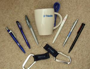
So there you have it. What crap are vendors giving away at this year’s show? Well, in comparison to the 2006 AGI trade show, it was a really poor affair, as evidenced by the photo. I’m thoroughly disappointed at how professional companies are becoming. I don’t really care that Topcon must have had over Ł250,000 of survey gear on their site. What I want is some really tasteless freebies. Pens were the order of the day; time will tell if they work (and on past experience the OS really score here). Faro gave away the best quality pen (perhaps matching the “Best Dressed Stand” award they received); the only one metal, but insider information (not mentioning any names Paul) suggests that quality insurance is lacking. As for the OS, pens were all they had. No crappy TOIDs this time around. Perhaps its time to tighten the belt at our national mapping agency. Leica had free pastries and coffee. Satisfaction for the stomach maybe, but quickly forgotten. Pentax had a flashy stand, with absolutely nothing of no-substance on it at all. Pointools tried to flagrantly buy off the judges with some paper anaglyph glasses and a Roses chocolate. Sorry guys, it won’t work. It’s sad to say, but even Kingston University was coming close to winning with some truly awful pens and magnets. I should give a brief mention to Positioning Systems with their globe stress balls; better than pens perhaps, but its so 90s that I couldn’t be bothered to actually pick one up.
Worst Tat
1. Pentax: far too professional for my liking. Avoid their stand like the plague.
2. OS: surely we can do something creative…..
Best Tat
1. Trimble: cracking mugs, although the spoons seem liable to snap
2. Trimble: great little karabiners
So the winner this time around is Trimble, awarded first and second place, taking the coveted crown away from AutoDesk. Well done guys.